Geolocate

Torre Cerredo topographic map

Click on the map to display elevation.

Torre Cerredo

Torre Cerredo,​ también nombrada Torrecerredo​ o Torre de Cerredo (en asturleonés, la Torre Cerréu),​ con sus 2650 m s. n. m., es la montaña de mayor altitud de Asturias y de Castilla y León, así como de la cordillera Cantábrica.​

Wikipedia (CC-BY-SA 3.0)

About this map

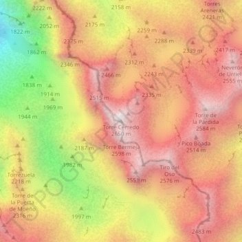
Name: Torre Cerredo topographic map, elevation, terrain.

Location: Torre Cerredo, Posada de Valdeón, León, Castilla y León, España (43.19771 -4.85292 43.19781 -4.85282)

Average elevation: 2,188 m

Minimum elevation: 1,487 m

Maximum elevation: 2,625 m

Other topographic maps

Click on a map to view its topography, its elevation and its terrain.

Gear up for your next adventure:

🧼Travel Hand Sanitizer - Keep hands clean when water is scarce
🛁Quick-Dry Microfiber Towel - Space-saving towel that dries rapidly on the move
🚲MTB Frame Bag - Carry tools and maps directly on your bicycle frame
💡LED Camping Lantern - Illuminate your campsite with long-lasting lanterns
💡Compact LED Flashlight - Powerful and portable flashlight for outdoor use

As an Amazon Associate, this site earns from qualifying purchases at no extra cost to you.