
Make a donation
Gear up for your next adventure:
As an Amazon Associate, this site earns from qualifying purchases at no extra cost to you.
Vega de Liordes topographic map
Click on the map to display elevation.
Make a donation
Gear up for your next adventure:
As an Amazon Associate, this site earns from qualifying purchases at no extra cost to you.
About this map
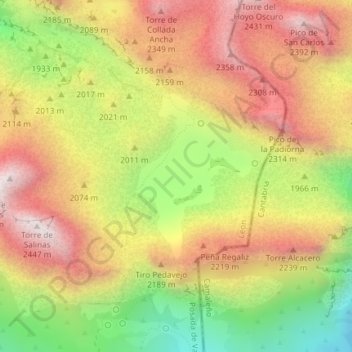
Name: Vega de Liordes topographic map, elevation, terrain.
Average elevation: 2,006 m
Minimum elevation: 1,509 m
Maximum elevation: 2,423 m
Make a donation
Gear up for your next adventure:
As an Amazon Associate, this site earns from qualifying purchases at no extra cost to you.
Other topographic maps
Click on a map to view its topography, its elevation and its terrain.
Torre Cerredo
España > Castilla y León > Posada de Valdeón
Torre Cerredo, también nombrada Torrecerredo o Torre de Cerredo (en asturleonés, la Torre Cerréu), con sus 2650 m s. n. m., es la montaña de mayor altitud de Asturias y de Castilla y León, así como de la cordillera Cantábrica.
Average elevation: 2,188 m
Make a donation
Gear up for your next adventure:
As an Amazon Associate, this site earns from qualifying purchases at no extra cost to you.
Torre Blanca
España > Castilla y León > Posada de Valdeón
Con sus 2618,5 metros de altitud representa el pico más alto de Cantabria, aunque tradicionalmente se ha otorgado este honor a Peña Vieja por encontrarse totalmente en territorio cántabro. Esta cumbre representa también el punto más occidental de la geografía cántabra.
Average elevation: 2,235 m