Geolocate

Periya topographic map

Click on the map to display elevation.

About this map

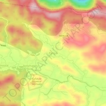
Name: Periya topographic map, elevation, terrain.

Location: Periya, Mananthavady, Wayanad, Kerala, 670552, India (11.81346 75.83502 11.85346 75.87502)

Average elevation: 774 m

Minimum elevation: 547 m

Maximum elevation: 929 m

Other topographic maps

Click on a map to view its topography, its elevation and its terrain.

Mazhuvannoor

India > Kerala > Mananthavady > Mazhuvannur

Average elevation: 733 m

Vellamunda

India > Kerala > Mananthavady > Peechamcode

Average elevation: 812 m

Kattikulam

India > Kerala > Mananthavady > Kattikkulam

Average elevation: 772 m

Gear up for your next adventure:

🧢Outdoor Visor - Breathable visor for sunny hikes
🛶Canoe Life Vest - Safety vest for water sports
🥾Lightweight Hiking Boots - Boots for comfort and mobility on long hikes
🪑Insulated Seat Pad - Protect your seat from cold rocks and wet logs
🧦Thermal Socks - Warm socks for winter hiking or camping

As an Amazon Associate, this site earns from qualifying purchases at no extra cost to you.