
Make a donation
Gear up for your next adventure:
As an Amazon Associate, this site earns from qualifying purchases at no extra cost to you.
Majdel Tarchich topographic map
Click on the map to display elevation.
Make a donation
Gear up for your next adventure:
As an Amazon Associate, this site earns from qualifying purchases at no extra cost to you.
About this map
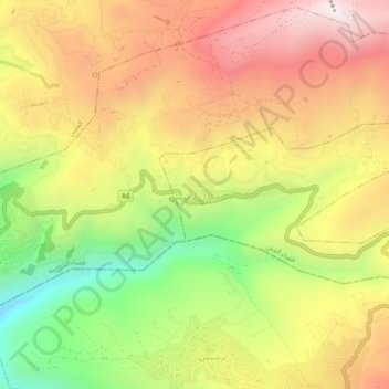
Name: Majdel Tarchich topographic map, elevation, terrain.
Average elevation: 1,508 m
Minimum elevation: 955 m
Maximum elevation: 1,996 m
Make a donation
Gear up for your next adventure:
As an Amazon Associate, this site earns from qualifying purchases at no extra cost to you.
Other topographic maps
Click on a map to view its topography, its elevation and its terrain.
District du Metn
Liban > Gouvernorat du Mont Liban
Le Caza du Metn (en arabe المتن), est un district situé dans le Gouvernorat du Mont-Liban, à l'est de la capitale, Beyrouth. La capitale du district est la ville de Jdeideh. Le district du Metn occupe une superficie de 265 kilomètres carrés. Il est délimité par les fleuves Nahr el Kalb au nord et…
Average elevation: 952 m
Make a donation
Gear up for your next adventure:
As an Amazon Associate, this site earns from qualifying purchases at no extra cost to you.
Make a donation
Gear up for your next adventure:
As an Amazon Associate, this site earns from qualifying purchases at no extra cost to you.
Make a donation
Gear up for your next adventure:
As an Amazon Associate, this site earns from qualifying purchases at no extra cost to you.
Make a donation
Gear up for your next adventure:
As an Amazon Associate, this site earns from qualifying purchases at no extra cost to you.