
Make a donation
Gear up for your next adventure:
As an Amazon Associate, this site earns from qualifying purchases at no extra cost to you.
Aintoura topographic map
Click on the map to display elevation.
Make a donation
Gear up for your next adventure:
As an Amazon Associate, this site earns from qualifying purchases at no extra cost to you.
About this map
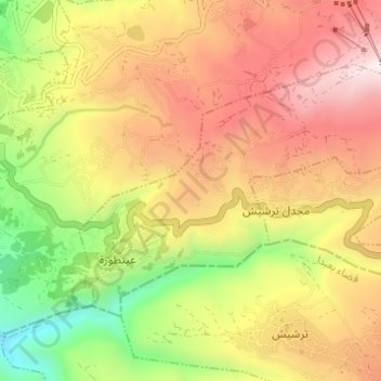
Name: Aintoura topographic map, elevation, terrain.
Location: Aintoura, Matn District, Mount Lebanon Governorate, Lebanon (33.87890 35.76877 33.91267 35.83009)
Average elevation: 1,411 m
Minimum elevation: 781 m
Maximum elevation: 1,986 m
Make a donation
Gear up for your next adventure:
As an Amazon Associate, this site earns from qualifying purchases at no extra cost to you.
Other topographic maps
Click on a map to view its topography, its elevation and its terrain.
Deir Al Qamar
Lebanon > Mount Lebanon Governorate
Deir al-Qamar (Arabic: دَيْر الْقَمَر, romanized: Dayr al-qamar, lit. 'Monastery of the moon') is a city south-east of Beirut in south-central Lebanon. It is located five kilometres outside of Beiteddine in the Chouf District of the Mount Lebanon Governorate at 800 m of average altitude.
Average elevation: 754 m
Aramoun
Lebanon > Mount Lebanon Governorate
Aramoun (Arabic: عرمون), often referred to as Dawhet Aramoun (Arabic: دوحة عرمون), is a village in the Aley District of Mount Lebanon, Lebanon, lying to the east of Khalde and 22 kilometres away from Beirut. Aramoun's altitude ranges between 250 meters to 600 meters further east. The village has…
Average elevation: 478 m
Make a donation
Gear up for your next adventure:
As an Amazon Associate, this site earns from qualifying purchases at no extra cost to you.
Antelias
Lebanon > Mount Lebanon Governorate
The municipality of Antelias - Naqqach is located in the Kaza of Metn in Mount Lebanon, one of the eight mohafazats (governorates) of Lebanon. Antelias - Naqqach is 8 kilometers (4.9712 mi) from Beyrouth (Beirut), the capital of Lebanon. Its elevation is 10 meters (32.81 ft; 10.936 yd) above sea level.…
Average elevation: 197 m
Make a donation
Gear up for your next adventure:
As an Amazon Associate, this site earns from qualifying purchases at no extra cost to you.
Make a donation
Gear up for your next adventure:
As an Amazon Associate, this site earns from qualifying purchases at no extra cost to you.
Nabay
Lebanon > Mount Lebanon Governorate
Nabay (Arabic: نابيه, from the Aramaic: נביא ; ܢܒܺܝܶ̈ܐ) is a village located in the Matn District (kada), Mount Lebanon Governorate (Mohafazat). Nabay is located 16 kilometers (9.9424 mi) away from the capital Beirut. Its elevation is 500 meters (1640.5 ft - 546.8 yd) above sea level. Nabay…
Average elevation: 443 m
Make a donation
Gear up for your next adventure:
As an Amazon Associate, this site earns from qualifying purchases at no extra cost to you.
Make a donation
Gear up for your next adventure:
As an Amazon Associate, this site earns from qualifying purchases at no extra cost to you.
Make a donation
Gear up for your next adventure:
As an Amazon Associate, this site earns from qualifying purchases at no extra cost to you.