Geolocate

Beacon topographic map

Click on the map to display elevation.

About this map

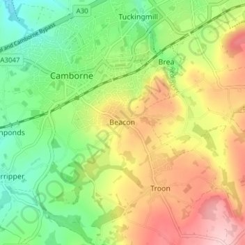
Name: Beacon topographic map, elevation, terrain.

Location: Beacon, Camborne, Cornwall, England, TR14 7SE, United Kingdom (50.18622 -5.30611 50.22622 -5.26611)

Average elevation: 125 m

Minimum elevation: 44 m

Maximum elevation: 229 m

Other topographic maps

Click on a map to view its topography, its elevation and its terrain.

Praze Stream

United Kingdom > England > Cornwall > Camborne > Barripper

Average elevation: 79 m

Gear up for your next adventure:

🥾Mountain Hiking Boots - High-traction boots for rocky terrain
🥘Camping Cookware Set - Compact nesting pots and pans for trail cooking
🥫Freeze-Dried Meals - Lightweight, high-calorie nutrition for multi-day treks
🥾Hiking Shoes - Durable and comfortable shoes for trail hiking
🥾Lightweight Hiking Boots - Boots for comfort and mobility on long hikes

As an Amazon Associate, this site earns from qualifying purchases at no extra cost to you.