Geolocate

Radcliff topographic map

Click on the map to display elevation.

About this map

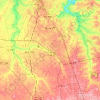
Name: Radcliff topographic map, elevation, terrain.

Location: Radcliff, Hardin County, Kentucky, 40160, United States (37.74857 -85.98154 37.87633 -85.88425)

Average elevation: 223 m

Minimum elevation: 145 m

Maximum elevation: 272 m

Other topographic maps

Click on a map to view its topography, its elevation and its terrain.

Eastview

United States > Kentucky > Hardin County

Average elevation: 231 m

Rineyville

United States > Kentucky > Hardin County

Average elevation: 242 m

Gaffey Heights

United States > Kentucky > Hardin County

Average elevation: 218 m

Limp

United States > Kentucky > Hardin County

Average elevation: 211 m

Cecil Hill

United States > Kentucky > Hardin County

Average elevation: 230 m

Kraft

United States > Kentucky > Hardin County

Average elevation: 247 m

West Point

United States > Kentucky > Hardin County > West Point

Average elevation: 169 m

Gear up for your next adventure:

🦌Outdoor Trail Camera - Monitor wildlife activity near your favorite spots
🦟Insect Repellent - Keep mosquitoes and black flies away in wooded areas
🚲MTB Frame Bag - Carry tools and maps directly on your bicycle frame
💡LED Headlamp - Hands-free illumination for night hiking and camping
🔥Emergency Fire Starter - Reliable ignition source for all weather conditions

As an Amazon Associate, this site earns from qualifying purchases at no extra cost to you.