Geolocate

Korome topographic map

Click on the map to display elevation.

About this map

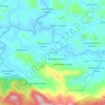
Name: Korome topographic map, elevation, terrain.

Location: Korome, Mananthavady, Wayanad, Kerala, 670731, India (11.72438 75.86157 11.76438 75.90157)

Average elevation: 783 m

Minimum elevation: 721 m

Maximum elevation: 995 m

Other topographic maps

Click on a map to view its topography, its elevation and its terrain.

Mazhuvannoor

India > Kerala > Mananthavady > Mazhuvannur

Average elevation: 733 m

Kattikulam

India > Kerala > Mananthavady > Kattikkulam

Average elevation: 772 m

Vellamunda

India > Kerala > Mananthavady > Peechamcode

Average elevation: 812 m

Gear up for your next adventure:

🛌Insulated Sleeping Pad - Critical thermal barrier between you and the cold ground
🛏️Sleeping Bag - Warm and compact sleeping bags for outdoor camping
🥾Waterproof Hiking Shoes - Durable shoes for wet and rugged trails
🧼Travel Hand Sanitizer - Keep hands clean when water is scarce
🔪Outdoor Multitool - Versatile tool for repairs and food prep in the wild

As an Amazon Associate, this site earns from qualifying purchases at no extra cost to you.