
Make a donation
Gear up for your next adventure:
As an Amazon Associate, this site earns from qualifying purchases at no extra cost to you.
Trenton topographic map
Click on the map to display elevation.
Make a donation
Gear up for your next adventure:
As an Amazon Associate, this site earns from qualifying purchases at no extra cost to you.
Trenton
According to the Köppen climate classification, Trenton lies in the northern range of the humid subtropical (Cfa) zone, and precipitation fairly evenly distributed through the year. The Cfa climate is the result of adiabatic warming of the Appalachians, low altitude and proximity to the coast without being on the immediate edge for moderate temperatures.
Make a donation
Gear up for your next adventure:
As an Amazon Associate, this site earns from qualifying purchases at no extra cost to you.
About this map
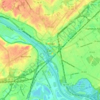
Name: Trenton topographic map, elevation, terrain.
Location: Trenton, Mercer County, New Jersey, United States (40.18383 -74.81958 40.24830 -74.72890)
Average elevation: 20 m
Minimum elevation: -1 m
Maximum elevation: 44 m
Make a donation
Gear up for your next adventure:
As an Amazon Associate, this site earns from qualifying purchases at no extra cost to you.
Other topographic maps
Click on a map to view its topography, its elevation and its terrain.
East Trenton Heights
United States > New Jersey > Mercer County > Hamilton Township
Average elevation: 22 m
Make a donation
Gear up for your next adventure:
As an Amazon Associate, this site earns from qualifying purchases at no extra cost to you.
Green Curve Heights
United States > New Jersey > Mercer County > Ewing Township
Average elevation: 40 m
Robbinsville
United States > New Jersey > Mercer County > Robbinsville Township
Average elevation: 32 m
Make a donation
Gear up for your next adventure:
As an Amazon Associate, this site earns from qualifying purchases at no extra cost to you.
Hillside Terrace
United States > New Jersey > Mercer County > Robbinsville Township
Average elevation: 35 m
Make a donation
Gear up for your next adventure:
As an Amazon Associate, this site earns from qualifying purchases at no extra cost to you.
Coopers Corner
United States > New Jersey > Mercer County > Hopewell Township
Average elevation: 104 m
Make a donation
Gear up for your next adventure:
As an Amazon Associate, this site earns from qualifying purchases at no extra cost to you.
Hamilton Square
United States > New Jersey > Mercer County > Hamilton Township
Average elevation: 29 m