
Barcombe topographic map
Click on the map to display elevation.
About this map
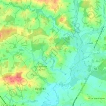
Name: Barcombe topographic map, elevation, terrain.
Location: Barcombe, Lewes, East Sussex, England, United Kingdom (50.90383 -0.00623 50.96129 0.05774)
Average elevation: 22 m
Minimum elevation: 2 m
Maximum elevation: 65 m
Other topographic maps
Click on a map to view its topography, its elevation and its terrain.
Ditchling Beacon
United Kingdom > England > East Sussex > Lewes
Ditchling Beacon is the highest point in East Sussex, England, with an elevation of 248 m (814 ft). It is south of Ditchling and to the north-east of Brighton. It is a large chalk hill with a particularly steep northern face, covered with open grassland and sheep-grazing areas. It is the third-highest point on…
Average elevation: 144 m
Kingston Near Lewes
United Kingdom > England > East Sussex > Lewes > Kingston Near Lewes
Average elevation: 65 m
South Heighton
United Kingdom > England > East Sussex > Lewes > South Heighton
Average elevation: 37 m