Geolocate

Daimús topographic map

Click on the map to display elevation.

About this map

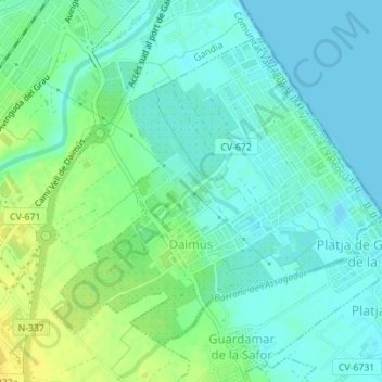
Name: Daimús topographic map, elevation, terrain.

Location: Daimús, la Safor, Valencia, Valencian Community, 46710, Spain (38.96167 -0.16592 38.98335 -0.13601)

Average elevation: 8 m

Minimum elevation: -1 m

Maximum elevation: 23 m

Other topographic maps

Click on a map to view its topography, its elevation and its terrain.

Pedralba

Spain > Valencian Community > La Serranía > Pedralba

Average elevation: 177 m

Valencia

Spain > Valencian Community > Valencia > Valencia

Average elevation: 44 m

Alcossebre

Spain > Valencian Community

Average elevation: 40 m

Santa Bàrbera

Spain > Valencian Community > Sant Mateu

Average elevation: 331 m

Moraira

Spain > Valencian Community

Average elevation: 40 m

Puntal de Aleto

Spain > Valencian Community > Chelva

Average elevation: 922 m

Tous

Spain > Valencian Community > Tous > Tous

Average elevation: 119 m

Calp

Spain > Valencian Community > Calp > Calp

Average elevation: 74 m

Oliva

Spain > Valencian Community > Oliva > Oliva

Average elevation: 51 m

San Juan

Spain > Valencian Community > Alicante

Average elevation: 110 m

Gear up for your next adventure:

🥾Durable Hiking Shoes - Long-lasting shoes for frequent hiking
🚲MTB Frame Bag - Carry tools and maps directly on your bicycle frame
🥾Hiking Shorts - Breathable shorts suitable for summer hikes
🦶Hiking Shoe Insoles - Added support for high arches and long days on feet
🥾Mountain Hiking Boots - High-traction boots for rocky terrain

As an Amazon Associate, this site earns from qualifying purchases at no extra cost to you.