Geolocate

Hesha topographic map

Click on the map to display elevation.

About this map

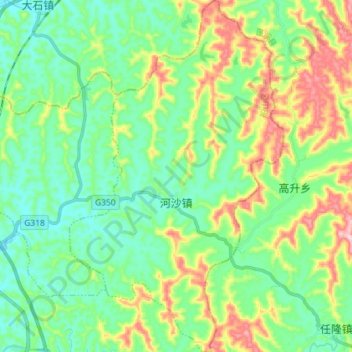
Name: Hesha topographic map, elevation, terrain.

Location: Hesha, Chuanshan District, Suining, Sichuan, China (30.53403 105.64901 30.65844 105.73686)

Average elevation: 365 m

Minimum elevation: 288 m

Maximum elevation: 541 m

Other topographic maps

Click on a map to view its topography, its elevation and its terrain.

Wanlin

China > Sichuan > Suining

Average elevation: 389 m

Wulang

China > Sichuan > Suining

Average elevation: 366 m

Gear up for your next adventure:

Camping Groundsheet - Protect your tent from moisture and dirt
🥾Trail Hiking Shoes - Durable shoes designed for rugged trails
🥾Hiking Leggings - Comfortable leggings for outdoor activities
🗺️Topographic Maps - Detailed maps to explore trails, mountains, and wilderness areas
🧴Sunscreen SPF - Broad-spectrum sunscreen for outdoor activities

As an Amazon Associate, this site earns from qualifying purchases at no extra cost to you.