
Make a donation
Gear up for your next adventure:
As an Amazon Associate, this site earns from qualifying purchases at no extra cost to you.
Schlattan topographic map
Click on the map to display elevation.
Make a donation
Gear up for your next adventure:
As an Amazon Associate, this site earns from qualifying purchases at no extra cost to you.
About this map
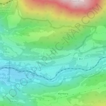
Name: Schlattan topographic map, elevation, terrain.
Average elevation: 1,016 m
Minimum elevation: 735 m
Maximum elevation: 1,662 m
Make a donation
Gear up for your next adventure:
As an Amazon Associate, this site earns from qualifying purchases at no extra cost to you.
Other topographic maps
Click on a map to view its topography, its elevation and its terrain.
Gatterl
Deutschland > Bayern > Landkreis Garmisch-Partenkirchen > Garmisch-Partenkirchen
Average elevation: 1,976 m
82467
Deutschland > Bayern > Landkreis Garmisch-Partenkirchen > Garmisch-Partenkirchen
Average elevation: 1,319 m
Kreuzeck
Deutschland > Bayern > Landkreis Garmisch-Partenkirchen > Garmisch-Partenkirchen
Das Skigebiet Kreuzeck auf 1340 m ü. NHN Höhe wurde aus Anlass der Olympischen Winterspiele 1936 angelegt. Die auch dort gelegene Kandahar-Abfahrt wird heute für Weltcuprennen genutzt. Zu erreichen ist das Kreuzeck mit der Kreuzeckbahn oder zu Fuß über Wanderwege. Direkt daran angeschlossen ist das…
Average elevation: 1,367 m
Alpspitze
Deutschland > Bayern > Landkreis Garmisch-Partenkirchen > Garmisch-Partenkirchen
Average elevation: 2,020 m
Make a donation
Gear up for your next adventure:
As an Amazon Associate, this site earns from qualifying purchases at no extra cost to you.
Zugspitzplatt
Deutschland > Bayern > Landkreis Garmisch-Partenkirchen > Garmisch-Partenkirchen
Average elevation: 2,378 m
Leutascher Dreitorspitze
Deutschland > Bayern > Landkreis Garmisch-Partenkirchen > Garmisch-Partenkirchen
Average elevation: 2,056 m
Wie Gemalt-Wettersteingebirge
Deutschland > Bayern > Landkreis Garmisch-Partenkirchen > Garmisch-Partenkirchen
Average elevation: 820 m
Eckbauer
Deutschland > Bayern > Landkreis Garmisch-Partenkirchen > Garmisch-Partenkirchen
Der Eckbauer besitzt einen Doppelgipfel, wobei der Westgipfel der höhere (1237 m ü. NHN) ist. Am höchsten Punkt befindet sich eine Hütte, etwas unterhalb ein Gipfelkreuz und etwa 100 m südwestlich vom Gipfel der Berggasthof Eckbauer. Auf dem Ostgipfel (1222 m ü. NHN) steht ebenfalls ein Gipfelkreuz, das…
Average elevation: 999 m
Make a donation
Gear up for your next adventure:
As an Amazon Associate, this site earns from qualifying purchases at no extra cost to you.
Kramerspitz
Deutschland > Bayern > Landkreis Garmisch-Partenkirchen > Garmisch-Partenkirchen
Average elevation: 1,438 m
Wildenau
Deutschland > Bayern > Landkreis Garmisch-Partenkirchen > Garmisch-Partenkirchen
Average elevation: 969 m
Predigtstuhl
Deutschland > Bayern > Landkreis Garmisch-Partenkirchen > Garmisch-Partenkirchen
Average elevation: 1,488 m
Äußere Höllentalspitze
Deutschland > Bayern > Landkreis Garmisch-Partenkirchen > Garmisch-Partenkirchen
Average elevation: 2,114 m
Make a donation
Gear up for your next adventure:
As an Amazon Associate, this site earns from qualifying purchases at no extra cost to you.
Wie Gemalt-Wettersteingebirge
Deutschland > Bayern > Landkreis Garmisch-Partenkirchen > Garmisch-Partenkirchen
Average elevation: 820 m