
Predigtstuhl topographic map
Click on the map to display elevation.
About this map
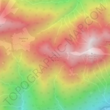
Name: Predigtstuhl topographic map, elevation, terrain.
Average elevation: 1,488 m
Minimum elevation: 867 m
Maximum elevation: 1,950 m
Other topographic maps
Click on a map to view its topography, its elevation and its terrain.
Schlattan
Deutschland > Bayern > Landkreis Garmisch-Partenkirchen > Garmisch-Partenkirchen
Average elevation: 1,016 m
82467
Deutschland > Bayern > Landkreis Garmisch-Partenkirchen > Garmisch-Partenkirchen
Average elevation: 1,319 m
Steingerümpel
Deutschland > Bayern > Landkreis Garmisch-Partenkirchen > Garmisch-Partenkirchen
Average elevation: 1,795 m
Pflegersee
Deutschland > Bayern > Landkreis Garmisch-Partenkirchen > Garmisch-Partenkirchen
Average elevation: 944 m
Jubiläumsgrat
Deutschland > Bayern > Landkreis Garmisch-Partenkirchen > Garmisch-Partenkirchen
Average elevation: 2,087 m
Schneeferner
Deutschland > Bayern > Landkreis Garmisch-Partenkirchen > Garmisch-Partenkirchen
Der Nördliche Schneeferner ist mit einer Fläche von etwa 9,4 ha (Stand 2025) der zweitgrößte der vier verbliebenen deutschen Gletscher. Mit einer mittleren Höhenlage von 2.630 m liegt er auch höher als die anderen deutschen Gletscher Höllentalferner, Watzmanngletscher und Blaueis. Seine Eisdicke wurde…
Average elevation: 2,310 m