
Bowie topographic map
Click on the map to display elevation.
About this map
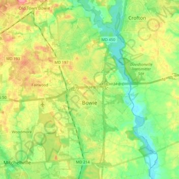
Name: Bowie topographic map, elevation, terrain.
Location: Bowie, Prince George's County, Maryland, United States (38.88649 -76.79987 39.01409 -76.69153)
Average elevation: 38 m
Minimum elevation: 2 m
Maximum elevation: 92 m
Other topographic maps
Click on a map to view its topography, its elevation and its terrain.
Sellman Estates
United States > Maryland > Prince George's County > Beltsville
Average elevation: 61 m
Mount Rainier Neighborhood Park
United States > Maryland > Prince George's County > Mount Rainier
Average elevation: 21 m
Farmington Road Estates
United States > Maryland > Prince George's County > Farmington Road Estates
Average elevation: 47 m