
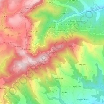
Les Ayats topographic map
Interactive map
Click on the map to display elevation.
About this map
Name: Les Ayats topographic map, elevation, terrain.
Average elevation: 604 m
Minimum elevation: 396 m
Maximum elevation: 804 m
Other topographic maps
Click on a map to view its topography, its elevation and its terrain.
Salcigneux
France > Auvergne-Rhône-Alpes > Loire > Cellieu
Salcigneux, Cellieu, Saint-Étienne, Loire, Auvergne-Rhône-Alpes, France métropolitaine, 42320, France
Average elevation: 430 m
Les Écheries
France > Auvergne-Rhône-Alpes > Loire > Cellieu
Les Écheries, Cellieu, Saint-Étienne, Loire, Auvergne-Rhône-Alpes, France métropolitaine, 42320, France
Average elevation: 633 m