
Make a donation
Gear up for your next adventure:
As an Amazon Associate, this site earns from qualifying purchases at no extra cost to you.
Großer Hermannsberg topographic map
Click on the map to display elevation.
Make a donation
Gear up for your next adventure:
As an Amazon Associate, this site earns from qualifying purchases at no extra cost to you.
About this map
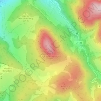
Name: Großer Hermannsberg topographic map, elevation, terrain.
Average elevation: 670 m
Minimum elevation: 487 m
Maximum elevation: 868 m
Make a donation
Gear up for your next adventure:
As an Amazon Associate, this site earns from qualifying purchases at no extra cost to you.
Other topographic maps
Click on a map to view its topography, its elevation and its terrain.
Steinbach-Hallenberg
Deutschland > Thüringen > Landkreis Schmalkalden-Meiningen > Steinbach-Hallenberg
Die Stadt liegt im Haseltal am Südwesthang des Thüringer Waldes (etwa 4 km südlich des Rennsteigs) in etwa 420 bis 470 m Höhe. Die Gewerbegebiete der Stadt finden sich im Wesentlichen in Herges-Hallenberg.
Average elevation: 609 m
Bermbach
Deutschland > Thüringen > Landkreis Schmalkalden-Meiningen > Steinbach-Hallenberg
Average elevation: 573 m
98587
Deutschland > Thüringen > Landkreis Schmalkalden-Meiningen > Steinbach-Hallenberg
Average elevation: 602 m
Viernau
Deutschland > Thüringen > Landkreis Schmalkalden-Meiningen > Steinbach-Hallenberg
Average elevation: 456 m
Make a donation
Gear up for your next adventure:
As an Amazon Associate, this site earns from qualifying purchases at no extra cost to you.
Oberschönau
Deutschland > Thüringen > Landkreis Schmalkalden-Meiningen > Steinbach-Hallenberg
Average elevation: 704 m