
Make a donation
Gear up for your next adventure:
As an Amazon Associate, this site earns from qualifying purchases at no extra cost to you.
Bermbach topographic map
Click on the map to display elevation.
Make a donation
Gear up for your next adventure:
As an Amazon Associate, this site earns from qualifying purchases at no extra cost to you.
About this map
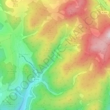
Name: Bermbach topographic map, elevation, terrain.
Average elevation: 573 m
Minimum elevation: 409 m
Maximum elevation: 777 m
Make a donation
Gear up for your next adventure:
As an Amazon Associate, this site earns from qualifying purchases at no extra cost to you.
Other topographic maps
Click on a map to view its topography, its elevation and its terrain.
Rotterode
Deutschland > Thüringen > Landkreis Schmalkalden-Meiningen > Steinbach-Hallenberg
Der Ort liegt am Südhang der Rotteroder Höhe (600 m) mit Blick zum Knüllfeld und zum Großen Hermannsberg. Westlich des Ortes erhebt sich der Hauptkamm des Thüringer Waldes, der Höhenweg Rennsteig ist rund 3 km entfernt. Rotterode verfügt über eine Bergwachtbereitschaft mit einer Hütte nahe dem…
Average elevation: 570 m
Herges-Hallenberg
Deutschland > Thüringen > Landkreis Schmalkalden-Meiningen > Steinbach-Hallenberg > Herges-Hallenberg
Average elevation: 469 m
Oberes Arntal
Deutschland > Thüringen > Landkreis Schmalkalden-Meiningen > Steinbach-Hallenberg > Bermbach
Average elevation: 659 m
Großer Hermannsberg
Deutschland > Thüringen > Landkreis Schmalkalden-Meiningen > Steinbach-Hallenberg
Average elevation: 670 m
Make a donation
Gear up for your next adventure:
As an Amazon Associate, this site earns from qualifying purchases at no extra cost to you.