Geolocate

De Beque topographic map

Click on the map to display elevation.

About this map

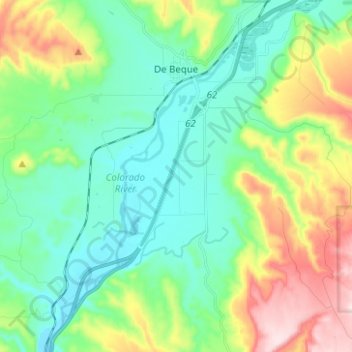
Name: De Beque topographic map, elevation, terrain.

Location: De Beque, Mesa County, Colorado, United States (39.25691 -108.22222 39.35346 -108.16632)

Average elevation: 1,597 m

Minimum elevation: 1,476 m

Maximum elevation: 1,889 m

Other topographic maps

Click on a map to view its topography, its elevation and its terrain.

Whitewater

United States > Colorado > Mesa County

Average elevation: 1,440 m

Glade Park

United States > Colorado > Mesa County

Average elevation: 2,110 m

Clifton

United States > Colorado > Mesa County

Average elevation: 1,431 m

Gear up for your next adventure:

🧥Ultralight Puffy Jacket - Maximum warmth that packs down to the size of an orange
🔭Compact Binoculars - Lightweight optics for scouting trails and wildlife
🔭Outdoor Binoculars - Lightweight binoculars for birdwatching and hiking
🥾Light Trekking Boots - Supportive boots for multi-day treks
🎒Hiking Daypack - Lightweight and durable backpacks for day trips and excursions

As an Amazon Associate, this site earns from qualifying purchases at no extra cost to you.