Geolocate

Whitewater topographic map

Click on the map to display elevation.

About this map

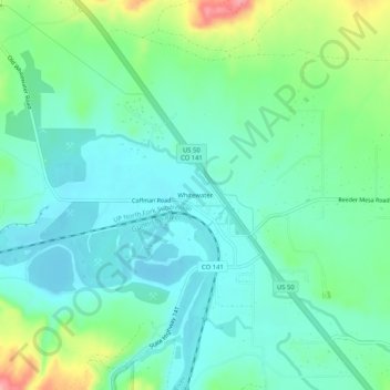
Name: Whitewater topographic map, elevation, terrain.

Location: Whitewater, Mesa County, Colorado, United States (38.97109 -108.47342 39.01109 -108.43342)

Average elevation: 1,440 m

Minimum elevation: 1,408 m

Maximum elevation: 1,531 m

Other topographic maps

Click on a map to view its topography, its elevation and its terrain.

Powderhorn Ski Area

United States > Colorado > Mesa County

Average elevation: 2,765 m

De Beque

United States > Colorado > Mesa County

Average elevation: 1,597 m

Clifton

United States > Colorado > Mesa County

Average elevation: 1,431 m

Gear up for your next adventure:

Bushcraft Tarp - Versatile emergency shelter or gear protection
🧥Waterproof Hiking Jacket - Protect yourself from rain and wind while hiking
🧤Insulated Winter Gloves - Heavy-duty protection for sub-zero Canadian adventures
🔭Compact Binoculars - Lightweight optics for scouting trails and wildlife
🔭Outdoor Binoculars - Lightweight binoculars for birdwatching and hiking

As an Amazon Associate, this site earns from qualifying purchases at no extra cost to you.