Geolocate

Talking Rock topographic map

Click on the map to display elevation.

About this map

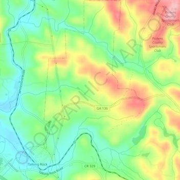
Name: Talking Rock topographic map, elevation, terrain.

Location: Talking Rock, Pickens County, Georgia, United States (34.50591 -84.50975 34.54384 -84.47806)

Average elevation: 383 m

Minimum elevation: 318 m

Maximum elevation: 477 m

Other topographic maps

Click on a map to view its topography, its elevation and its terrain.

Talmadge

United States > Georgia > Pickens County

Average elevation: 378 m

Marble Hill

United States > Georgia > Pickens County

Average elevation: 404 m

Ludville

United States > Georgia > Pickens County

Average elevation: 364 m

Gear up for your next adventure:

🧢Sun Hat - Wide-brim hat for sun protection
🧶550 Survival Paracord - Versatile utility cord for emergency repairs and rigging
🧥Ultralight Puffy Jacket - Maximum warmth that packs down to the size of an orange
🦶Anti-Blister Balm - Prevents friction and hotspots during long ascents
🔦LED Headlamp - Hands-free lighting for early morning starts or late finishes

As an Amazon Associate, this site earns from qualifying purchases at no extra cost to you.