
Make a donation
Gear up for your next adventure:
As an Amazon Associate, this site earns from qualifying purchases at no extra cost to you.
Grupont topographic map
Click on the map to display elevation.
Make a donation
Gear up for your next adventure:
As an Amazon Associate, this site earns from qualifying purchases at no extra cost to you.
About this map
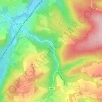
Name: Grupont topographic map, elevation, terrain.
Location: Grupont, Tellin, Neufchâteau, Luxemburg, Wallonië, België (50.07029 5.27047 50.09853 5.31662)
Average elevation: 296 m
Minimum elevation: 222 m
Maximum elevation: 383 m
Make a donation
Gear up for your next adventure:
As an Amazon Associate, this site earns from qualifying purchases at no extra cost to you.
Other topographic maps
Click on a map to view its topography, its elevation and its terrain.
Région Famenne et Calestienne
België > Luxemburg > Neufchâteau > Saint-Hubert
Average elevation: 359 m
Make a donation
Gear up for your next adventure:
As an Amazon Associate, this site earns from qualifying purchases at no extra cost to you.
Make a donation
Gear up for your next adventure:
As an Amazon Associate, this site earns from qualifying purchases at no extra cost to you.
Make a donation
Gear up for your next adventure:
As an Amazon Associate, this site earns from qualifying purchases at no extra cost to you.
Make a donation
Gear up for your next adventure:
As an Amazon Associate, this site earns from qualifying purchases at no extra cost to you.
Make a donation
Gear up for your next adventure:
As an Amazon Associate, this site earns from qualifying purchases at no extra cost to you.
Fourneau Saint-Michel
België > Luxemburg > Neufchâteau > Saint-Hubert
Op een open plek in het bos staan twee musea die gewijd zijn aan het leven in het verleden van deze streek. De laatste abt van de Sint-Hubertusabdij, Nicolas Spirlet (1715-1794), richtte hier in 1771 een ijzergieterij en hoogoven in bij de Masbelette. Nadat in het vervolg van de Franse Revolutie de kerkelijke…
Average elevation: 391 m
Make a donation
Gear up for your next adventure:
As an Amazon Associate, this site earns from qualifying purchases at no extra cost to you.
Make a donation
Gear up for your next adventure:
As an Amazon Associate, this site earns from qualifying purchases at no extra cost to you.
Make a donation
Gear up for your next adventure:
As an Amazon Associate, this site earns from qualifying purchases at no extra cost to you.
Bonance
België > Luxemburg > Neufchâteau > Libramont > Libramont-Chevigny > Bonance
Average elevation: 499 m