Geolocate

Chakrata topographic map

Click on the map to display elevation.

About this map

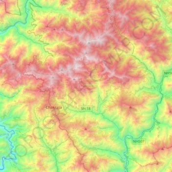
Name: Chakrata topographic map, elevation, terrain.

Location: Chakrata, Dehradun, Uttarakhand, India (30.61354 77.74624 30.86199 78.08365)

Average elevation: 1,745 m

Minimum elevation: 602 m

Maximum elevation: 3,026 m

Other topographic maps

Click on a map to view its topography, its elevation and its terrain.

Myunda

India > Uttarakhand > Chakrata

Average elevation: 1,581 m

Gear up for your next adventure:

👖Convertible Hiking Pants - Zip-off legs to adapt to changing weather conditions
🎒Fully Waterproof Backpack - Total protection for photography gear and electronics
Family Camping Tent - Spacious tent suitable for family camping trips
🥾Trail Hiking Socks - Comfortable socks to prevent blisters and fatigue
🥾Hiking Shoes - Durable and comfortable shoes for trail hiking

As an Amazon Associate, this site earns from qualifying purchases at no extra cost to you.