
Make a donation
Gear up for your next adventure:
As an Amazon Associate, this site earns from qualifying purchases at no extra cost to you.
Folding Mountain topographic map
Click on the map to display elevation.
Make a donation
Gear up for your next adventure:
As an Amazon Associate, this site earns from qualifying purchases at no extra cost to you.
About this map
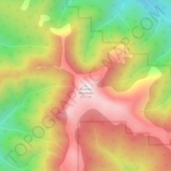
Name: Folding Mountain topographic map, elevation, terrain.
Location: Folding Mountain, Yellowhead County, Alberta, Canada (53.21264 -117.70480 53.21274 -117.70470)
Average elevation: 1,806 m
Minimum elevation: 1,440 m
Maximum elevation: 2,114 m
Yellowhead County trails, hiking, mountain biking, running and outdoor activities
Make a donation
Gear up for your next adventure:
As an Amazon Associate, this site earns from qualifying purchases at no extra cost to you.
Other topographic maps
Click on a map to view its topography, its elevation and its terrain.
Brazeau River Provincial Recreation Area
Canada > Alberta > Yellowhead County
Average elevation: 1,325 m
Make a donation
Gear up for your next adventure:
As an Amazon Associate, this site earns from qualifying purchases at no extra cost to you.
William A. Switzer Provincial Park
Canada > Alberta > Yellowhead County
This park is situated within the foothills of Alberta's Rocky Mountains, at an elevation of 1,150 m (3,770 ft) to 1,300 m (4,300 ft) and has a surface of 93 km2 (36 sq mi). It was established on December 22, 1958 and is maintained by Alberta Tourism, Parks and Recreation. The park is named after former…
Average elevation: 1,348 m