Geolocate

Prospect topographic map

Click on the map to display elevation.

About this map

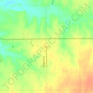
Name: Prospect topographic map, elevation, terrain.

Location: Prospect, Butler County, Kansas, United States (37.78696 -96.80919 37.82696 -96.76919)

Average elevation: 417 m

Minimum elevation: 393 m

Maximum elevation: 435 m

Other topographic maps

Click on a map to view its topography, its elevation and its terrain.

Andover

United States > Kansas > Butler County

Average elevation: 406 m

Augusta

United States > Kansas > Butler County

Average elevation: 387 m

Cassoday

United States > Kansas > Butler County

Average elevation: 450 m

El Dorado

United States > Kansas > Butler County

Average elevation: 405 m

Whitewater

United States > Kansas > Butler County

Average elevation: 419 m

El Dorado

United States > Kansas > Butler County

Average elevation: 405 m

El Dorado

United States > Kansas > Butler County

Average elevation: 405 m

Gear up for your next adventure:

💡Compact LED Flashlight - Powerful and portable flashlight for outdoor use
Camping Coffee Maker - Brew fresh coffee anywhere on the topographic map
🛶Waterproof Dry Bags - Keep electronics and clothes dry during river crossings
❄️Traction Ice Cleats - Slip-on spikes for icy trails and winter hiking
🧥Insulated Jacket - Keep warm in cold outdoor conditions

As an Amazon Associate, this site earns from qualifying purchases at no extra cost to you.