Geolocate

Chestermere topographic map

Click on the map to display elevation.

About this map

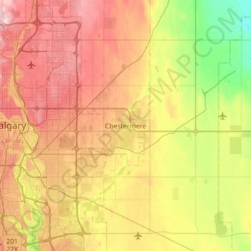
Name: Chestermere topographic map, elevation, terrain.

Location: Chestermere, Alberta, T1X 1V3, Canada (50.88485 -113.98111 51.20485 -113.66111)

Average elevation: 1,032 m

Minimum elevation: 936 m

Maximum elevation: 1,145 m

Alberta trails, hiking, mountain biking, running and outdoor activities

Gear up for your next adventure:

🦌Outdoor Trail Camera - Monitor wildlife activity near your favorite spots
Backpacking Tent - Lightweight tent for long-distance hiking trips
🥤Collapsible Travel Cup - Saves space and weight in your mess kit
🚲Heavy Duty Bike Lock - Secure your bike at the trailhead or during stops
🧦Hiking Socks - Moisture-wicking and comfortable socks for long hikes

As an Amazon Associate, this site earns from qualifying purchases at no extra cost to you.