Geolocate

Munster topographic map

Click on the map to display elevation.

About this map
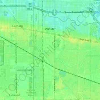
Name: Munster topographic map, elevation, terrain.

Location: Munster, North Township, Lake County, Indiana, 46321, United States (41.52261 -87.52550 41.58139 -87.48062)

Average elevation: 187 m

Minimum elevation: 180 m

Maximum elevation: 194 m

Other topographic maps

Click on a map to view its topography, its elevation and its terrain.
Cook

United States > Indiana > Lake County > Cedar Lake

Average elevation: 222 m

Ross

United States > Indiana > Lake County

Average elevation: 194 m

Miller

United States > Indiana > Lake County > Gary > Miller

Average elevation: 186 m

Lake Seven

United States > Indiana > Lake County > Crown Point

Average elevation: 220 m

Liverpool

United States > Indiana > Lake County > Lake Station

Average elevation: 191 m

Triangle Parkway

United States > Indiana > Lake County > Hammond

Average elevation: 184 m

Illinoi

United States > Indiana > Lake County

Average elevation: 192 m

Glen Park

United States > Indiana > Lake County > Gary

Average elevation: 193 m

Gear up for your next adventure:

🚑Survival Whistle - Signal for help across long distances in mountains
🧴Insect Repellent - Protect yourself from bugs during outdoor adventures
🚲MTB Frame Bag - Carry tools and maps directly on your bicycle frame
🧢Outdoor Cap - Protective cap for sun and rain during hikes
🛶Kayak Accessories - Essential gear for safe and fun kayaking adventures

As an Amazon Associate, this site earns from qualifying purchases at no extra cost to you.