Geolocate

Bagnoregio topographic map

Click on the map to display elevation.

About this map

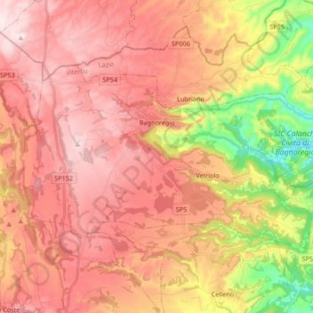
Name: Bagnoregio topographic map, elevation, terrain.

Location: Bagnoregio, Viterbo, Lazio, 01022, Italy (42.57768 12.01081 42.64944 12.17718)

Average elevation: 438 m

Minimum elevation: 129 m

Maximum elevation: 637 m

Other topographic maps

Click on a map to view its topography, its elevation and its terrain.

Monte Raschio

Italy > Lazio > Viterbo > Oriolo Romano

Average elevation: 448 m

Bagnaia

Italy > Lazio > Viterbo > Viterbo

Average elevation: 464 m

Isola Bisentina

Italy > Lazio > Viterbo > Capodimonte

Average elevation: 304 m

Cura

Italy > Lazio > Viterbo > Vetralla

Average elevation: 393 m

Gear up for your next adventure:

🥾Light Hiking Boots - Lightweight and comfortable boots for day hikes
🧥Waterproof Jacket - Lightweight rain jackets for hiking and outdoor activities
🥾Waterproof Trail Shoes - Shoes designed to handle wet terrain
🧊Portable Cooler - Keep food and drinks cold during outdoor adventures
🧰Survival Kit - Essential gear for emergencies in the wilderness

As an Amazon Associate, this site earns from qualifying purchases at no extra cost to you.