Make a donation
Gear up for your next adventure:
As an Amazon Associate, this site earns from qualifying purchases at no extra cost to you.
Province of Paruro topographic map
Click on the map to display elevation.
Make a donation
Gear up for your next adventure:
As an Amazon Associate, this site earns from qualifying purchases at no extra cost to you.
Province of Paruro
The provincial capital of Paruro, with population of 3,855, lies at 3,057 meters (10,032 ft) altitude. Two and a half hours by bus from Cusco, in the bottom of a deep valley, it is bordered on one side by the Rio Paruro, a feeder of the Apurímac River. A number of small Inca and pre-Inca ruins are in the area, and a series of arches built by Simón Bolívar to celebrate a victory over the Spaniards.
Make a donation
Gear up for your next adventure:
As an Amazon Associate, this site earns from qualifying purchases at no extra cost to you.
About this map
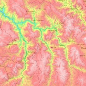
Name: Province of Paruro topographic map, elevation, terrain.
Location: Province of Paruro, Cusco, 08565, Peru (-14.27879 -72.23286 -13.59363 -71.67339)
Average elevation: 3,819 m
Minimum elevation: 2,267 m
Maximum elevation: 4,948 m
Make a donation
Gear up for your next adventure:
As an Amazon Associate, this site earns from qualifying purchases at no extra cost to you.
Other topographic maps
Click on a map to view its topography, its elevation and its terrain.
Make a donation
Gear up for your next adventure:
As an Amazon Associate, this site earns from qualifying purchases at no extra cost to you.
Make a donation
Gear up for your next adventure:
As an Amazon Associate, this site earns from qualifying purchases at no extra cost to you.
Make a donation
Gear up for your next adventure:
As an Amazon Associate, this site earns from qualifying purchases at no extra cost to you.
Make a donation
Gear up for your next adventure:
As an Amazon Associate, this site earns from qualifying purchases at no extra cost to you.
