Geolocate

Zurite topographic map

Click on the map to display elevation.

About this map

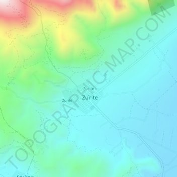
Name: Zurite topographic map, elevation, terrain.

Location: Zurite, Province of Anta, Cusco, Peru (-13.47352 -72.27578 -13.43352 -72.23578)

Average elevation: 3,523 m

Minimum elevation: 3,322 m

Maximum elevation: 4,218 m

Gear up for your next adventure:

🔭Compact Monocular - One-handed bird watching and trail spotting
🍽️Titanium Camping Spork - Ultralight and indestructible eating utensil
🥾Trekking Poles - Adjustable trekking poles to reduce knee stress and improve stability
🧣Evaporative Cooling Towel - Beat the heat during intense summer climbs
🧴Sunscreen SPF - Broad-spectrum sunscreen for outdoor activities

As an Amazon Associate, this site earns from qualifying purchases at no extra cost to you.