
Province of Acomayo topographic map
Interactive map
Click on the map to display elevation.
About this map
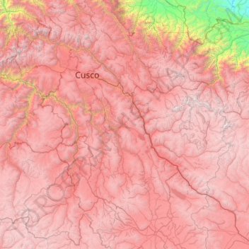
Name: Province of Acomayo topographic map, elevation, terrain.
Location: Province of Acomayo, Cusco, Peru, Province of Acomayo (-14.91667 -72.66667 -12.91667 -70.66667)
Average elevation: 3,814 m
Minimum elevation: 304 m
Maximum elevation: 6,142 m
Other topographic maps
Click on a map to view its topography, its elevation and its terrain.
Vilcabamba
Vilcabamba District is one of fourteen districts of the La Convención Province in the Cusco Region in Peru. The capital of the province is the Centro Poblado Lucma, which has an elevation of 2,943 metres (9,656 ft). Vitcos was an important city of the Neo-Inca State (1537-1572). Its ruins are now preserved as…
Average elevation: 2,770 m
Province of Paruro
The provincial capital of Paruro, with population of 3,855, lies at 3,057 meters (10,032 ft) altitude. Two and a half hours by bus from Cusco, in the bottom of a deep valley, it is bordered on one side by the Rio Paruro, a feeder of the Apurímac River. A number of small Inca and pre-Inca ruins are in the…
Average elevation: 3,819 m
Province of La Convención
La Convención province is approximately 220 km (140 mi) long from north to south. Within that distance, the land of La Convención reaches has a maximum elevation of 6,264 m (20,551 ft) at Salcantay, on the border of La Convención, Anta, and Urubamba provinces, and a minimum elevation of 284 m (932 ft) in…
Average elevation: 1,804 m