Geolocate

Hindon topographic map

Click on the map to display elevation.

About this map

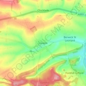
Name: Hindon topographic map, elevation, terrain.

Location: Hindon, Wiltshire, England, SP3 6ER, United Kingdom (51.07506 -2.14664 51.11506 -2.10664)

Average elevation: 155 m

Minimum elevation: 96 m

Maximum elevation: 221 m

Other topographic maps

Click on a map to view its topography, its elevation and its terrain.

Trowbridge

United Kingdom > England > Wiltshire

Average elevation: 47 m

Corsham

United Kingdom > England > Wiltshire

Average elevation: 98 m

Silbury Hill

United Kingdom > England > Wiltshire > Beckhampton

Average elevation: 166 m

Berwick St. John

United Kingdom > England > Wiltshire

Average elevation: 168 m

Southwick

United Kingdom > England > Wiltshire

Average elevation: 57 m

Marden

United Kingdom > England > Wiltshire

Average elevation: 139 m

Amesbury

United Kingdom > England > Wiltshire > Amesbury

Average elevation: 103 m

Whiteparish

United Kingdom > England > Wiltshire

Average elevation: 74 m

Gear up for your next adventure:

🔪Outdoor Multitool - Versatile tool for repairs and food prep in the wild
🥾Trail Hiking Boots - Supportive boots for rough trails
🥾Mountain Trail Shoes - High-traction shoes for mountain trails
💡Compact LED Flashlight - Powerful and portable flashlight for outdoor use
🧣Merino Neck Gaiter - Protects against wind, sun, and cold at high altitudes

As an Amazon Associate, this site earns from qualifying purchases at no extra cost to you.