Geolocate

Southwick topographic map

Click on the map to display elevation.

About this map

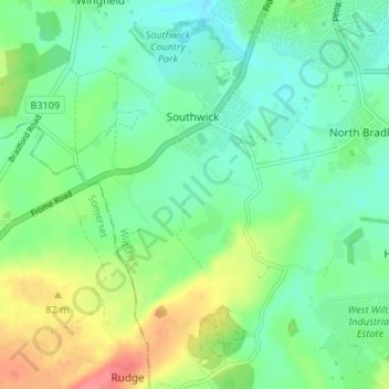
Name: Southwick topographic map, elevation, terrain.

Location: Southwick, Wiltshire, England, United Kingdom (51.26762 -2.28150 51.30939 -2.21558)

Average elevation: 57 m

Minimum elevation: 36 m

Maximum elevation: 98 m

Other topographic maps

Click on a map to view its topography, its elevation and its terrain.

Lea

United Kingdom > England > Wiltshire

Average elevation: 82 m

Silbury Hill

United Kingdom > England > Wiltshire > Beckhampton

Average elevation: 166 m

Hindon

United Kingdom > England > Wiltshire

Average elevation: 155 m

West Kennett

United Kingdom > England > Wiltshire

Average elevation: 174 m

Gear up for your next adventure:

🥾Approach Shoes - Shoes designed for climbing approaches and rugged trails
🍽️Titanium Camping Spork - Ultralight and indestructible eating utensil
🔭Compact Monocular - One-handed bird watching and trail spotting
🔋Emergency Crank Radio - Weather alerts and power without needing batteries
🧳Compression Sacks - Maximize space in your backpack by shrinking gear

As an Amazon Associate, this site earns from qualifying purchases at no extra cost to you.