Geolocate

Leonardtown topographic map

Click on the map to display elevation.

About this map

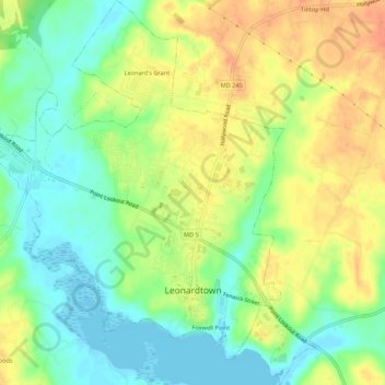
Name: Leonardtown topographic map, elevation, terrain.

Location: Leonardtown, Saint Mary's County, Maryland, United States (38.28005 -76.66678 38.32489 -76.61469)

Average elevation: 22 m

Minimum elevation: -2 m

Maximum elevation: 45 m

Other topographic maps

Click on a map to view its topography, its elevation and its terrain.

Hurry

United States > Maryland > Saint Mary's County

Average elevation: 34 m

Avenue

United States > Maryland > Saint Mary's County

Average elevation: 3 m

Gear up for your next adventure:

🎒Backpack Rain Cover - External shield to keep your entire pack dry
🔭Outdoor Binoculars - Lightweight binoculars for birdwatching and hiking
Lightweight Backpacking Tent - Compact tent for efficient hiking trips
🎒Hiking Daypack - Lightweight and durable backpacks for day trips and excursions
Camping Essentials - All-in-one gear for a comfortable camping trip

As an Amazon Associate, this site earns from qualifying purchases at no extra cost to you.