
Hurry topographic map
Click on the map to display elevation.
About this map
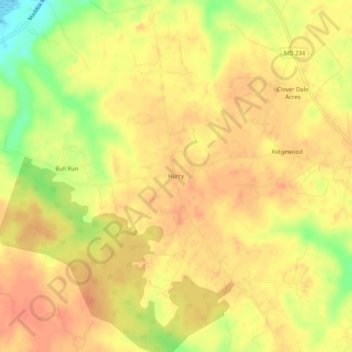
Name: Hurry topographic map, elevation, terrain.
Location: Hurry, Saint Mary's County, Maryland, 20621, United States (38.31707 -76.79552 38.35707 -76.75552)
Average elevation: 34 m
Minimum elevation: -1 m
Maximum elevation: 48 m
Other topographic maps
Click on a map to view its topography, its elevation and its terrain.
St. George Island
United States > Maryland > Saint Mary's County > Piney Point > Saint George Island
Average elevation: 0 m
Mechanicsville
United States > Maryland > Saint Mary's County > Mechanicsville
Average elevation: 46 m
Charlotte Hall
United States > Maryland > Saint Mary's County > Charlotte Hall
Average elevation: 49 m
Lexington Park
United States > Maryland > Saint Mary's County > Lexington Park
Average elevation: 24 m
Lexington Park
United States > Maryland > Saint Mary's County > Lexington Park
Average elevation: 24 m
Mechanicsville
United States > Maryland > Saint Mary's County > Mechanicsville
Average elevation: 46 m
Lexington Park
United States > Maryland > Saint Mary's County > Lexington Park
Average elevation: 24 m