Geolocate

甘山 topographic map

Click on the map to display elevation.

About this map

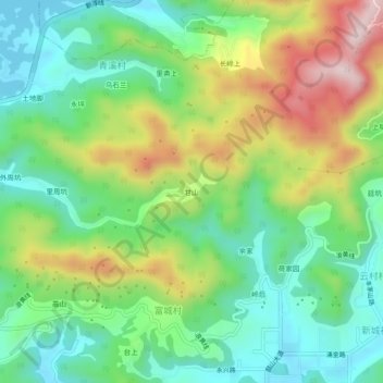
Name: 甘山 topographic map, elevation, terrain.

Location: 甘山, Chun'an County, Hangzhou City, Zhejiang, China (29.61087 119.06737 29.65087 119.10737)

Average elevation: 250 m

Minimum elevation: 99 m

Maximum elevation: 521 m

Gear up for your next adventure:

🧭GPS Tracker - Track your location in remote areas safely
🧼Travel Hand Sanitizer - Keep hands clean when water is scarce
🛶Kayak Accessories - Essential gear for safe and fun kayaking adventures
🧢Hiking Sun Hat - Wide-brimmed protection for exposed mountain ridges
🥾Approach Shoes - Shoes designed for climbing approaches and rugged trails

As an Amazon Associate, this site earns from qualifying purchases at no extra cost to you.