Geolocate

Cuasso al Monte topographic map

Click on the map to display elevation.

About this map

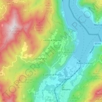
Name: Cuasso al Monte topographic map, elevation, terrain.

Location: Cuasso al Monte, Comunità Montana del Piambello, Varese, Lombardy, Italy (45.88251 8.83740 45.93560 8.89756)

Average elevation: 562 m

Minimum elevation: 263 m

Maximum elevation: 1,102 m

Other topographic maps

Click on a map to view its topography, its elevation and its terrain.

Pianbosco

Italy > Lombardy > Varese > Venegono Inferiore

Average elevation: 368 m

Due Cossani

Italy > Lombardy > Varese

Average elevation: 599 m

Santa Maria del monte

Italy > Lombardy > Varese > Varese

Average elevation: 689 m

Orocco

Italy > Lombardy > Varese > Comerio

Average elevation: 408 m

Vizzola Ticino

Italy > Lombardy > Varese > Vizzola Ticino

Average elevation: 197 m

Case Nuove

Italy > Lombardy > Varese > Somma Lombardo

Average elevation: 218 m

Biumo Superiore

Italy > Lombardy > Varese > Varese

Average elevation: 395 m

Castegnate

Italy > Lombardy > Varese > Castellanza > Castegnate

Average elevation: 221 m

Gear up for your next adventure:

🎒Hiking Daypack - Lightweight and durable backpacks for day trips and excursions
🧥Waterproof Jacket - Lightweight rain jackets for hiking and outdoor activities
💧Hydration Pack - Hands-free hydration system for long hikes
🛁Quick-Dry Microfiber Towel - Space-saving towel that dries rapidly on the move
🧤Rechargeable Heated Gloves - Extreme warmth for Canadian winter expeditions

As an Amazon Associate, this site earns from qualifying purchases at no extra cost to you.