
Make a donation
Gear up for your next adventure:
As an Amazon Associate, this site earns from qualifying purchases at no extra cost to you.
Town of Kent topographic map
Click on the map to display elevation.
Make a donation
Gear up for your next adventure:
As an Amazon Associate, this site earns from qualifying purchases at no extra cost to you.
About this map
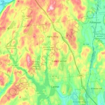
Name: Town of Kent topographic map, elevation, terrain.
Location: Town of Kent, Putnam County, New York, 10512, United States (41.42838 -73.83714 41.51761 -73.64753)
Average elevation: 217 m
Minimum elevation: 89 m
Maximum elevation: 399 m
Make a donation
Gear up for your next adventure:
As an Amazon Associate, this site earns from qualifying purchases at no extra cost to you.
Other topographic maps
Click on a map to view its topography, its elevation and its terrain.
Oscawana Corners
United States > New York > Putnam County > Town of Putnam Valley
Average elevation: 158 m
Make a donation
Gear up for your next adventure:
As an Amazon Associate, this site earns from qualifying purchases at no extra cost to you.
Lake Peekskill
United States > New York > Putnam County > Town of Putnam Valley
Average elevation: 103 m
Make a donation
Gear up for your next adventure:
As an Amazon Associate, this site earns from qualifying purchases at no extra cost to you.
Barnum Corners
United States > New York > Putnam County > Town of Patterson > Putnam Lake
Average elevation: 174 m
Lake Tonetta
United States > New York > Putnam County > Brewster > Brewster Hill
Average elevation: 155 m
Make a donation
Gear up for your next adventure:
As an Amazon Associate, this site earns from qualifying purchases at no extra cost to you.
Crofts Corners
United States > New York > Putnam County > Town of Putnam Valley
Average elevation: 141 m
Make a donation
Gear up for your next adventure:
As an Amazon Associate, this site earns from qualifying purchases at no extra cost to you.
Stillwater Pond
United States > New York > Putnam County > Town of Putnam Valley
Average elevation: 288 m
Kent Cliffs Unit
United States > New York > Putnam County > Town of Putnam Valley > Richardsville
Average elevation: 270 m
Make a donation
Gear up for your next adventure:
As an Amazon Associate, this site earns from qualifying purchases at no extra cost to you.
Tompkins Corners
United States > New York > Putnam County > Town of Putnam Valley
Average elevation: 208 m
Make a donation
Gear up for your next adventure:
As an Amazon Associate, this site earns from qualifying purchases at no extra cost to you.