
Graymoor topographic map
Click on the map to display elevation.
About this map
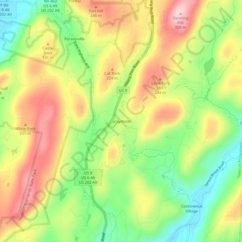
Name: Graymoor topographic map, elevation, terrain.
Average elevation: 167 m
Minimum elevation: 43 m
Maximum elevation: 300 m
Other topographic maps
Click on a map to view its topography, its elevation and its terrain.
Nimham Mountain Multiple Use Area
United States > New York > Putnam County > Lake Carmel
Average elevation: 228 m
Brewster Heights
United States > New York > Putnam County > Brewster > Brewster Heights
Average elevation: 146 m
Lake Tonetta
United States > New York > Putnam County > Brewster > Brewster Hill
Average elevation: 155 m
Clarence Fahnestock Memorial State Park
United States > New York > Putnam County > Town of Putnam Valley
Average elevation: 207 m
Kent Cliffs Unit
United States > New York > Putnam County > Town of Putnam Valley > Richardsville
Average elevation: 270 m
Stillwater Pond
United States > New York > Putnam County > Town of Putnam Valley
Average elevation: 288 m