Geolocate

Huanggang topographic map

Click on the map to display elevation.

About this map

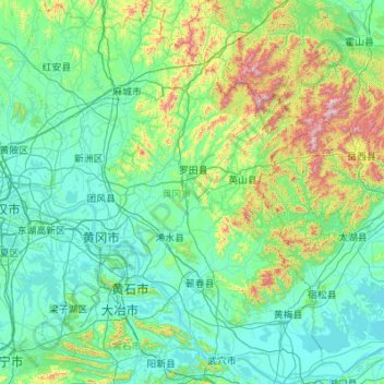
Name: Huanggang topographic map, elevation, terrain.

Location: Huanggang, Hubei, China (29.72375 114.39721 31.60806 116.13218)

Average elevation: 143 m

Minimum elevation: 8 m

Maximum elevation: 1,679 m

Other topographic maps

Click on a map to view its topography, its elevation and its terrain.

Bahe

China > Hubei > Huanggang

Average elevation: 19 m

Xinghua

China > Hubei > Huanggang

Average elevation: 67 m

Guankou

China > Hubei > Huanggang

Average elevation: 64 m

Wuxue

China > Hubei > Huanggang > Shichuan

Average elevation: 94 m

Gear up for your next adventure:

👟Leg Gaiters - Keep debris, mud, and snow out of your boots
🧢Hiking Hat - Sun-protective and breathable hats for long treks
🧦Hiking Liner Socks - Thin base layer to prevent friction and blisters
🦶Anti-Blister Balm - Prevents friction and hotspots during long ascents
🦌Outdoor Trail Camera - Monitor wildlife activity near your favorite spots

As an Amazon Associate, this site earns from qualifying purchases at no extra cost to you.