
Lumbutts topographic map
Click on the map to display elevation.
About this map
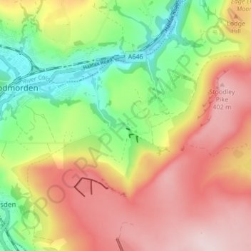
Name: Lumbutts topographic map, elevation, terrain.
Average elevation: 268 m
Minimum elevation: 115 m
Maximum elevation: 421 m
Other topographic maps
Click on a map to view its topography, its elevation and its terrain.
Ragby Plantation
United Kingdom > England > Calderdale > Todmorden > Walsden > Bottoms
Average elevation: 293 m
Gaddings Dam
United Kingdom > England > Calderdale > Todmorden > Walsden
Gaddings Dam is a locally owned reservoir near to Todmorden in West Yorkshire, England. The dam was built to power water mills in the Todmorden area, being superseded by steam power and left redundant. It is notable for having a sandy beach at the north-eastern side which attracts people to it during the…
Average elevation: 283 m