Geolocate

Tibig topographic map

Click on the map to display elevation.

About this map

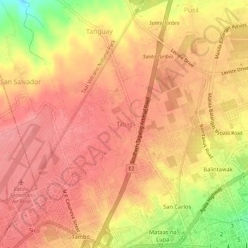
Name: Tibig topographic map, elevation, terrain.

Location: Tibig, Lipa, Batangas, Calabarzon, 4217, Philippines (13.94163 121.12462 13.98163 121.16462)

Average elevation: 352 m

Minimum elevation: 287 m

Maximum elevation: 377 m

Other topographic maps

Click on a map to view its topography, its elevation and its terrain.

Lipa City Community Park

Philippines > Batangas > Lipa

Average elevation: 311 m

Malepunyo Mountain Range

Philippines > Batangas > Lipa

Average elevation: 295 m

Pangao

Philippines > Batangas > Lipa

Average elevation: 324 m

Pinagkawitan

Philippines > Batangas > Lipa

Average elevation: 223 m

Sabang

Philippines > Batangas > Lipa

Average elevation: 324 m

Tambo

Philippines > Batangas > Lipa

Average elevation: 353 m

6

Philippines > Batangas > Lipa

Average elevation: 313 m

Lumbang

Philippines > Batangas > Lipa

Average elevation: 347 m

Halang

Philippines > Batangas > Lipa > Halang

Average elevation: 171 m

Pangao

Philippines > Batangas > Lipa

Average elevation: 324 m

Sabang

Philippines > Batangas > Lipa

Average elevation: 324 m

Gear up for your next adventure:

🔦LED Headtorch - Bright and durable light for night activities
🧦Thermal Socks - Warm socks for winter hiking or camping
🏕️Camping Hammock - Integrated protection for sleeping between trees
🚲Heavy Duty Bike Lock - Secure your bike at the trailhead or during stops
🕶️Polarized Sunglasses - Protect your eyes with durable polarized lenses

As an Amazon Associate, this site earns from qualifying purchases at no extra cost to you.