Geolocate

Cabadbaran topographic map

Click on the map to display elevation.

About this map
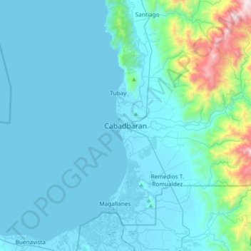
Name: Cabadbaran topographic map, elevation, terrain.

Location: Cabadbaran, Agusan del Norte, Caraga, 8605, Philippines (8.96329 125.37223 9.28329 125.69223)

Average elevation: 179 m

Minimum elevation: -2 m

Maximum elevation: 1,751 m

Other topographic maps

Click on a map to view its topography, its elevation and its terrain.

Kitcharao

Philippines > Agusan del Norte

Average elevation: 293 m

Las Nieves

Philippines > Agusan del Norte

Average elevation: 113 m

Cabadbaran River

Philippines > Agusan del Norte

Average elevation: 722 m

Las Nieves

Philippines > Agusan del Norte

Average elevation: 113 m

Las Nieves

Philippines > Agusan del Norte

Average elevation: 113 m

Gear up for your next adventure:

🦯Trekking Poles - Reduced impact on joints for steep topographic climbs
🥾Approach Boots - Comfortable boots for hiking and climbing approaches
🧤Insulated Winter Gloves - Heavy-duty protection for sub-zero Canadian adventures
🔭Compact Binoculars - Lightweight optics for scouting trails and wildlife
🥾Waterproof Hiking Boots - Essential footwear for rugged terrain and wet Canadian trails

As an Amazon Associate, this site earns from qualifying purchases at no extra cost to you.