Geolocate

Puerto Caicedo topographic map

Click on the map to display elevation.

About this map

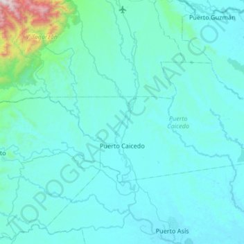
Name: Puerto Caicedo topographic map, elevation, terrain.

Location: Puerto Caicedo, Putumayo, 862080, Colombia (0.60361 -76.76594 0.86698 -76.23343)

Average elevation: 383 m

Minimum elevation: 238 m

Maximum elevation: 2,668 m

Other topographic maps

Click on a map to view its topography, its elevation and its terrain.

Cerro Patascoy

Colombia > Putumayo > Orito

Average elevation: 3,475 m

Puerto Guzmán

Colombia > Putumayo > Puerto Guzmán

Average elevation: 272 m

Puerto Guzmán

Colombia > Putumayo > Puerto Guzmán

Average elevation: 272 m

Mecaya

Colombia > Putumayo > Puerto Leguízamo

Average elevation: 189 m

Sibundoy

Colombia > Putumayo > Sibundoy > Sibundoy

Average elevation: 2,302 m

Cerro Patascoy

Colombia > Putumayo > Orito

Average elevation: 3,468 m

Gear up for your next adventure:

🥾Trail Running Boots - Durable shoes designed for trail running
Camping Groundsheet - Protect your tent from moisture and dirt
💡Compact LED Flashlight - Powerful and portable flashlight for outdoor use
🥫Freeze-Dried Meals - Lightweight, high-calorie nutrition for multi-day treks
🧥Thermal Layer - Insulating layer for cold outdoor conditions

As an Amazon Associate, this site earns from qualifying purchases at no extra cost to you.