Geolocate

Mecaya topographic map

Click on the map to display elevation.

About this map

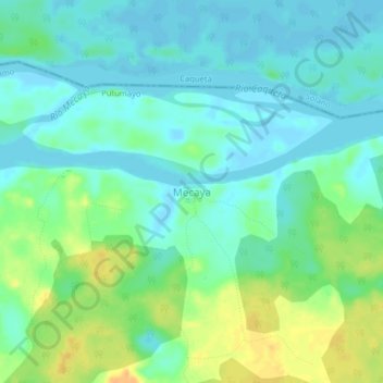
Name: Mecaya topographic map, elevation, terrain.

Location: Mecaya, Puerto Leguízamo, Putumayo, RAP Amazonía, Colombia (0.45387 -75.19413 0.49387 -75.15413)

Average elevation: 189 m

Minimum elevation: 179 m

Maximum elevation: 210 m

Gear up for your next adventure:

🚲Bike Repair Kit - Essential tools for on-trail mechanical issues
🎒Hiking Daypack - Lightweight and durable backpacks for day trips and excursions
🛌Down Sleeping Bag - Superior warmth-to-weight ratio for cold nights
🚲Handlebar Phone Mount - View topographic-map.com live while cycling
💧Collapsible Water Bottle - Space-saving water bottle for outdoor activities

As an Amazon Associate, this site earns from qualifying purchases at no extra cost to you.