Geolocate

Patti topographic map

Click on the map to display elevation.

About this map

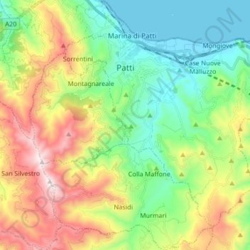
Name: Patti topographic map, elevation, terrain.

Location: Patti, Messina, Sicily, 98066, Italy (38.07215 14.93224 38.15768 15.06491)

Average elevation: 385 m

Minimum elevation: 0 m

Maximum elevation: 1,085 m

Other topographic maps

Click on a map to view its topography, its elevation and its terrain.

Monte Serro

Italy > Sicily > Messina > Messina

Average elevation: 92 m

Sperone

Italy > Sicily > Messina > Messina

Average elevation: 56 m

Castel di Tusa

Italy > Sicily > Messina

Average elevation: 96 m

Messina

Italy > Sicily > Messina > Messina

Average elevation: 180 m

Gear up for your next adventure:

🔥Camping Stove - Portable stoves to cook outdoors with ease
🥾Mountain Trail Shoes - High-traction shoes for mountain trails
🎒Fully Waterproof Backpack - Total protection for photography gear and electronics
🔦LED Flashlight - Powerful and long-lasting flashlight for camping and emergencies
🛌Down Sleeping Bag - Superior warmth-to-weight ratio for cold nights

As an Amazon Associate, this site earns from qualifying purchases at no extra cost to you.