Geolocate

Deer River topographic map

Click on the map to display elevation.

About this map

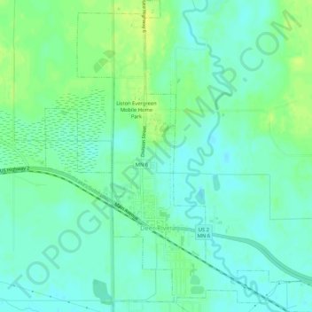
Name: Deer River topographic map, elevation, terrain.

Location: Deer River, Itasca County, Minnesota, United States (47.32320 -93.81150 47.35867 -93.76038)

Average elevation: 393 m

Minimum elevation: 386 m

Maximum elevation: 404 m

Other topographic maps

Click on a map to view its topography, its elevation and its terrain.

Togo

United States > Minnesota > Itasca County

Average elevation: 408 m

Upper Twin Lakes

United States > Minnesota > Itasca County > Rosy

Average elevation: 409 m

Candy Lake

United States > Minnesota > Itasca County

Average elevation: 421 m

Gear up for your next adventure:

🥾Mountaineering Boots - Supportive boots for climbing and high-altitude hiking
🧦Hiking Liner Socks - Thin base layer to prevent friction and blisters
🧴Sunscreen SPF - Broad-spectrum sunscreen for outdoor activities
🔨Vehicle Emergency Tool - Safety tool for remote road trips to trailheads
🥾Mountain Hiking Boots - High-traction boots for rocky terrain

As an Amazon Associate, this site earns from qualifying purchases at no extra cost to you.