Geolocate

Jacobstow topographic map

Click on the map to display elevation.

About this map

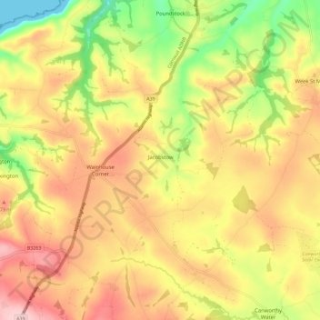
Name: Jacobstow topographic map, elevation, terrain.

Location: Jacobstow, Cornwall, England, United Kingdom (50.69698 -4.58289 50.76896 -4.51271)

Average elevation: 127 m

Minimum elevation: 0 m

Maximum elevation: 234 m

Other topographic maps

Click on a map to view its topography, its elevation and its terrain.

Trembraze

United Kingdom > England > Cornwall > Liskeard

Average elevation: 128 m

Freathy

United Kingdom > England > Cornwall

Average elevation: 37 m

Riviere Towans

United Kingdom > England > Cornwall > Hayle > Phillack

Average elevation: 19 m

Pinnacle Gully

United Kingdom > England > Cornwall > Porthgwarra

Average elevation: 19 m

Gear up for your next adventure:

🧢Hiking Sun Hat - Wide-brimmed protection for exposed mountain ridges
🥾Trekking Boots - Durable boots for long-distance trekking
🥾Light Trekking Boots - Supportive boots for multi-day treks
🧼Biodegradable Camp Soap - Environmentally friendly cleaning for gear and body
🎒Hiking Backpack - Lightweight and ergonomic backpacks for day hikes or multi-day treks

As an Amazon Associate, this site earns from qualifying purchases at no extra cost to you.