
Make a donation
Gear up for your next adventure:
As an Amazon Associate, this site earns from qualifying purchases at no extra cost to you.
Wipptal - Alta Vall'Isarco topographic map
Click on the map to display elevation.
Make a donation
Gear up for your next adventure:
As an Amazon Associate, this site earns from qualifying purchases at no extra cost to you.
About this map
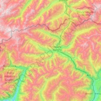
Name: Wipptal - Alta Vall'Isarco topographic map, elevation, terrain.
Average elevation: 1,903 m
Minimum elevation: 385 m
Maximum elevation: 3,452 m
Make a donation
Gear up for your next adventure:
As an Amazon Associate, this site earns from qualifying purchases at no extra cost to you.
Other topographic maps
Click on a map to view its topography, its elevation and its terrain.
St. Valentin auf der Haide - San Valentino alla Muta
Italië > Trentino-Zuid-Tirol > Bolzano - Bozen > Graun - Curon Venosta
Average elevation: 1,755 m
Jochgrimm - Passo Oclini
Italië > Trentino-Zuid-Tirol > Bolzano - Bozen > Aldein - Aldino
Average elevation: 1,994 m
Make a donation
Gear up for your next adventure:
As an Amazon Associate, this site earns from qualifying purchases at no extra cost to you.
Frëina
Italië > Trentino-Zuid-Tirol > Bolzano - Bozen > Sëlva - Wolkenstein - Selva di Val Gardena
Average elevation: 1,830 m
Pfunders - Fundres
Italië > Trentino-Zuid-Tirol > Bolzano - Bozen > Vintl - Vandoies
Average elevation: 1,604 m
Ums - Umes
Italië > Trentino-Zuid-Tirol > Bolzano - Bozen > Völs am Schlern - Fiè allo Sciliar
Average elevation: 1,123 m
Make a donation
Gear up for your next adventure:
As an Amazon Associate, this site earns from qualifying purchases at no extra cost to you.
Ellen - Elle
Italië > Trentino-Zuid-Tirol > Bolzano - Bozen > St. Lorenzen - San Lorenzo di Sebato
Average elevation: 1,348 m
Schnalstal
Italië > Trentino-Zuid-Tirol > Bolzano - Bozen > Schnals - Senales
Aan het einde van het dal ligt het wintersportoord Kurzras, dat een van de oudste en grootste stoeltjesliftinstallaties van Zuid-Tirol bezit, de Schnalstaler Gletscherbahnen. Het skigebied Schnalstal, onderdeel van de Ortler Skiarena, heeft meer dan 35 kilometer piste en reikt van 2011 tot 3212 meter hoogte.…
Average elevation: 2,167 m
Palmschoß - Plancios
Italië > Trentino-Zuid-Tirol > Bolzano - Bozen > Brixen - Bressanone
Average elevation: 1,717 m
Make a donation
Gear up for your next adventure:
As an Amazon Associate, this site earns from qualifying purchases at no extra cost to you.
Antermëia - Untermoi - Antermoia
Italië > Trentino-Zuid-Tirol > Bolzano - Bozen > San Martin de Tor - San Martino in Badia - St. Martin in Thurn
Average elevation: 1,677 m
Plan de Gralba
Italië > Trentino-Zuid-Tirol > Bolzano - Bozen > Sëlva - Wolkenstein - Selva di Val Gardena
Average elevation: 2,095 m
Make a donation
Gear up for your next adventure:
As an Amazon Associate, this site earns from qualifying purchases at no extra cost to you.
Taisten - Tesido
Italië > Trentino-Zuid-Tirol > Bolzano - Bozen > Welsberg-Taisten - Monguelfo-Tesido
Average elevation: 1,357 m
Sulden - Solda
Italië > Trentino-Zuid-Tirol > Bolzano - Bozen > Stilfs - Stelvio
Average elevation: 2,232 m
Plattenalm - Alpe Piatta
Italië > Trentino-Zuid-Tirol > Bolzano - Bozen > Villanders - Villandro
Average elevation: 2,161 m
Make a donation
Gear up for your next adventure:
As an Amazon Associate, this site earns from qualifying purchases at no extra cost to you.
Prad am Stilfser Joch - Prato allo Stelvio
Italië > Trentino-Zuid-Tirol > Bolzano - Bozen > Prad am Stilfserjoch - Prato allo Stelvio
Average elevation: 1,078 m
Sacun - St. Jakob - San Giacomo
Italië > Trentino-Zuid-Tirol > Bolzano - Bozen > Urtijëi - St. Ulrich in Gröden - Ortisei
Average elevation: 1,594 m
Weiern
Italië > Trentino-Zuid-Tirol > Bolzano - Bozen > Freienfeld - Campo di Trens > Elzenbaum - Pruno > Weiern
Average elevation: 1,228 m
Gossensaß - Colle Isarco
Italië > Trentino-Zuid-Tirol > Bolzano - Bozen > Brenner - Brennero > Gossensaß - Colle Isarco
Average elevation: 1,433 m
Make a donation
Gear up for your next adventure:
As an Amazon Associate, this site earns from qualifying purchases at no extra cost to you.
St. Jakob - S. Giacomo
Italië > Trentino-Zuid-Tirol > Bolzano - Bozen > Brixen - Bressanone > St. Jakob - S. Giacomo
Average elevation: 1,168 m
Schluderbach - Carbonin
Italië > Trentino-Zuid-Tirol > Bolzano - Bozen > Toblach - Dobbiaco
Average elevation: 1,776 m
Make a donation
Gear up for your next adventure:
As an Amazon Associate, this site earns from qualifying purchases at no extra cost to you.