
Make a donation
Gear up for your next adventure:
As an Amazon Associate, this site earns from qualifying purchases at no extra cost to you.
Schnalstal topographic map
Click on the map to display elevation.
Make a donation
Gear up for your next adventure:
As an Amazon Associate, this site earns from qualifying purchases at no extra cost to you.
Schnalstal
Aan het einde van het dal ligt het wintersportoord Kurzras, dat een van de oudste en grootste stoeltjesliftinstallaties van Zuid-Tirol bezit, de Schnalstaler Gletscherbahnen. Het skigebied Schnalstal, onderdeel van de Ortler Skiarena, heeft meer dan 35 kilometer piste en reikt van 2011 tot 3212 meter hoogte. Het liftstation dat hier in juli 1975 werd geopend is het hoogstgelegen station in Zuid-Tirol. Skiën in de gletsjerskigebieden die aan het eind van het dal aanwezig zijn is het hele jaar mogelijk.
Make a donation
Gear up for your next adventure:
As an Amazon Associate, this site earns from qualifying purchases at no extra cost to you.
About this map
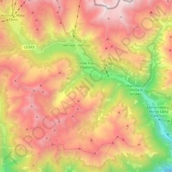
Name: Schnalstal topographic map, elevation, terrain.
Average elevation: 2,167 m
Minimum elevation: 543 m
Maximum elevation: 3,596 m
Make a donation
Gear up for your next adventure:
As an Amazon Associate, this site earns from qualifying purchases at no extra cost to you.